
Golden Hinde Traverse 2023
- Alyssa Russell
- Aug 8, 2023
- 14 min read
Updated: Aug 9, 2023
(Last updated in August 2023)
If you have never heard of the Golden Hinde, it's the tallest mountain on Vancouver Island in the Strathcona Park. This amazing mountain stands the tallest at 2195m and is classified as an Island Qualifier. Most people get this objective by using the standard route called Phillips Ridge as an out-and-back trail. This was the original plan back when my friend Brodie and I planned this after we did Elkhorn of last summer. However when Brodie pitched this traverse to me, we didn't hesitate to change the plan a week prior to leaving. I watched countless videos, blogs, and read as much information as I possibly could to get familiar with the landscape I was about to engulf myself in. I'm not going to lie when the track said it's 65 km with elevation gains and losses of over 4100 m - it made me a little nervous. It's really no wonder why people need to get rescued from the Golden Hinde yearly. It's a push to even get to the base let alone to the summit. Every trip report shared how their bodies felt "shattered" or described as the "hardest thing I've ever done" now you can see how I might have had some nerves going into it as I also knew it would be the hardest thing to date I would do (for now.)
The Golden Hinde was first ascended in 1913 back when trails did not exist and the most popular route that used to be taken was through the Wolf River Valley. It is very much overgrown now and why the Phillips Ridge Route has become to date a very worn in popular trail to access the hinde from. The Golden Hinde Traverse from the Elk River Trail also known as the way to get to the popular trail Landslide Lake, is the way we were going to come in by. If you aren't sure what a traverse means, it is a trail we travel across or go through vs going back the same way. This required a drop off of two cars at two different trailheads. We parked my car at the Westmin Rd - Phillips Ridge parking area and Brodie's truck off at the Elk River Trail. A whole traverse done in 25 minutes in a car - it is crazy to think about the kilometres we were about to put on our feet while transferring vehicles.

Before I begin how our time went, I would like to point out that this is rated severe and difficult. I trained for this for a year before I did something like this. That included carrying my son on more challenging day hikes to get my body used to heavy weight on my back and covering multiple hikes a week to get my body used to the elevation gain and loss. I can't stress enough being physically and mentally prepared for this - is an absolute must if you ever try to challenge this yourself. I have never felt so ready for something in my life - other than child birth. This mountain wasn't ready for me if anything because I knew I was ready to tackle this beast. Now let's begin the journey.
DAY 1: ELK RIVER TRAIL TO ELK PASS CAMP (20 KMS)
Thursday August 3rd:
It's a beautiful August morning, my alarm was not set and I slept in. Go figure - not to worry my friend Brodie was just passing Nanaimo as he lives in Duncan. So I wasn't to far behind, I quickly brushed my teeth and set out to grab Tim Hortons. I had pre-packed my car so everything was ready to go the night before. We met at the Campbell River McDonalds, grabbed coffee and set out to drop my car off at Westmin Mine Rd otherwise known as the Phillips Ridge parking lot. Once we got my car situated and backpack swapped into Brodie's truck we set out for the Elk River Trail knowing it was going to be awhile before we sat down again. I have done this trail plenty of times but never veering off of it, so I was pretty excited to explore territory I've never set foot in. The first part of the Elk River Trail is mostly chill and flat. To get to where we needed to veer off we had already done around 11K. I knew the elevation was just going to get crazier, so I enjoyed the groomed Landslide Lake trail for the beginning stages of our quest.

I would like to give a shout out to Casey, Brodie's friend. We met up with him right away at the Elk River Trailhead - he is working as a park ranger this summer. We hiked with him and had good conversation until Brodie and I veered off to Elk Pass. I realized during this section I had forgotten my keys in Brodie's truck lol. So much for a Traverse, Brodie actually asked if he needed to run back to his truck. We were already so far away at this point and it would have taken over an hour to turn around. I asked Casey if he could potentially drop off my keys at my car being that he was going to Bedwell in a couple of days which is near where my car was parked. Bless him and he was able to, glad we figured that out then and not when we had completed the traverse! Makes for an interesting story when things like that happen.


Going through Elk Pass was a bit overgrown, you can see there is wear and there's a couple camps you pass being Hemlock and Elk Pass Camp. This area is very beautiful and seeing Elkhorn in so many different angles was cool. I do believe a lot of climbers access this trail to do Rambler as well. It's narrow in some sections and the bushes have definitely taken over, it seems that some people were in there a couple years back with a machete however. We were passing rivers, passing through mountains and really just taking it all in. This was a big day we decided we weren't going to camp at Elk Pass Camp and would continue past the bowl between Rambler & Mt. Slocum - camping down below after some mild (mild to me LOL) bushwhacking to get to this tarn. We had roughly done 20K and we were feeling pretty tired. We set up camp, made food, watched the sun go down and prepared for another gruelling day.


DAY 2: CAMP 1 SPOT TO DEVOE RIDGE (8KMS+)
Friday August 4th:
If I can recommend anything - it's to camp on a ridge with higher elevation. The bugs won't nearly be as bad and you'll get morning sun. Due to us camping near so much water and in a bowl of a valley it was hard to get the morning going. It's August but there is that dew that covered everything in the morning. I wasn't motivated to get out of the tent. We didn't get packed up until 8-8:30AM, I had my oats and protein bar and was ready for the next set of views. I will tell you everyone told me to pack A-LOT of food, I practically had a full on deli on my back. My food weighed the most, both our packs weighed around 50 pounds. I had enough food to survive out here for 2 weeks. We were here for five LOL! lessoned learned.
DeVoe Ridge, an iconic spot I had read lots of blogs about how beautiful it is and I was so excited for this journey to this ridge. It was a bit slow going as getting to this ridge took some route finding and judgment of weaknesses and stable terrain. We had to lose some elevation which meant bushwhacking down (oh great, here we go again.) I actually don't mind bushwhacking it makes it interesting and fun. I like the challenge it brings to navigate through it. Getting to the marked camp spot on this un named lake/tarn took almost two hours from where we camped just to give you an idea of what that bushwhacking was like. It looks like something that would maybe take 30 minutes or less had it been a trail.

As we began going up the ridge past Mount DeVoe and down to the Wolf-Ucona Rivers Divide to get to DeVoe Ridge, we stopped up and had some breaks as the views were amazing. Brodie always setting up the BIG AGNES chair, a necessity we both agreed to purchase for this trip. A lightweight camping chair just hit the spot after long days. It's 12:30 and we still have so much to cover to get to DeVoe ridge, this day was around 10-11K I'm pretty sure with lots of elevation gain and loss. If you went down, you would go right back up. This was trending for the whole trip. We never really stayed flat for awhile and if we did we really appreciated it. After some more bush-whacking as we had to descent once more to get up on the ridge we stopped at another tarn and I went for a swim. It felt so good to get some sweat of me and feel re-charged to start our uphill grind to DeVoe Ridge. This was epic, took some route finding and good judgment calls but we finally made it to where we wanted to set up camp for the night as we didn't feel like pushing past 6:30PM.

We had good food, listened to some tunes and smoked a joint watching the sun go down with being right in-front of the Golden Hinde. This was so epic, on the other side we could see so many mountains and Donner Lake in the background. We stayed up later this night as the weather was just amazing and oh my god that sunset.


DAY 3: DEVOE RIDGE TO GOLDEN HINDE COL CAMP (10KMS?+)
Saturday August 5th:

This morning was a breeze with the exception of the hornets wanting to kill us. We didn't want to get out of the tent because of them LOL! The bugs weren't terrible, I mean it's August in the alpine what do you expect. We were feeling motivated and set off for our next part of our journey which meant camping right behind the Golden Hinde and Behinde. How exciting. There is one part that we located in the distance that looked STEEP AF going up but I assured myself, it probably just looks crazy from over here - once we are up close and personal it won't be so bad and my judgement later was correct.
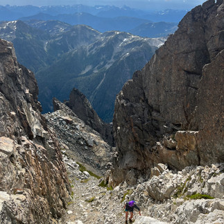
Hiking through DeVoe Ridge was endless so many up and downs, you think in your head "Ridge" all of it is flat. Yeah right this is the heart of the Strathcona it's crazy terrain. I loved this part because the views were endless and so motivating, it's better than being in that thick bush let me tell you. As we were nearing the last bump of the ridge we had to start making our way down and cross the valley to hit the scree/boulder field from where the Behinde starts. The scary part that looked vertical from a distance. It honestly was not bad the bushwhacking and route finding was more daunting prior, I was just happy to not be in the thick bush. Climbing up this scree took a bit of time and we were making a good pace for ourselves, taking as many water breaks as we needed being so exposed to the blazing hot sun. We had to skirt across a waterfall and do some minor class 4 moves that were a bit exposed - a bit of a challenge with the heavy ass backpacks on but nothing we couldn't handle. Just be strong and make sure you don't fall!

We got up the steep scree bank and made our way to the tarn in the bowl of the Behinde and Ridge there. I convinced Brodie to take a dip with me as it was freaking hot out and we were sweaty and stinky. Make sure to properly filter water for this reason LOL! I'm not skipping out on a swim because this might be drinking water for some. Bring the filters and you'll be A-OKAY. Once we got refreshed from the icy blue tarn we started hiking up the ridge line of the Behinde, set up our camp - which was the best camp spot during this whole trip. I mean can you complain about this view. Golden Hinde baby - I'll summit you tomorrow. Brodie was hoping to summit the Behinde while this really wasn't in my book of objectives - it was for him and we made the choice together I was fine to set up camp while he left me alone and billy goated his way up the Behinde. I danced, sang and ventured around camp. Plenty of tarns of water up here, ample really. It was a great spot for being so close to both the Behinde and the Golden Hinde. Putting you in an optimal spot to summit both if you wanted to in a days time. We got to our camp later around 3PM making this attainable for Brodie to get that Behinde summit that day.


It had actually briefly rained for 10 minutes - I was in my tent around 5:30pm I heard a voice, what do you know it's Brodie already back from summiting the Behinde. Damn mountain goat. I'm glad I didn't try to summit this as he said the top was very exposed. I wanted to save all my energy for the big beast tomorrow : THE GOLDEN HINDE. We enjoyed each-others company and watched the most amazing sunset we'd both probably ever laid eyes on. Time for sleep - the alarm was set for 5:30AM for the big summit day.

DAY 4: SUMMIT DAY OF GH TO SCHJELDERUP LAKE (12KMS+?)
Sunday August 6th:

Brodie's alarm went off at 5:30AM and we had everything prepared the night before in our summit bags. We quickly got ready and set off for the West Ridge (4th class, 500M) of the Golden Hinde BABY! The night before we discussed and read in the Island Alpine book the route and felt confident without a track and basing the directions solely on the book. We started on the easy heather ledges and quickly started our ascent. Going up the gendarme was a super cool feature, we knew after that we had to skirt across the red terrace and make our way to the quartzite wall which led to this super cool chimney, lots of exposure on this route which was so neat and enthralling. Next came a bit more of a exposed ledge/wall but lots of good jugs and holds. Finally to making our way over top of the last shoulder of rock and began our way to the summit which was a super easy move. Not sure why anyone would go another way, especially the most popular way as it looks like loose shitty rock and dirt - nothing about that chimney looked appealing to me. A few people going up the SE gullies mentioned if there was a better way and we said West Ridge all the way. The SE gullies is only 4th class and 250 metres but like I said just looks like not a very fun route.


The summit what a beautiful pivotal moment in our trek, I finally made it to Vancouver Island's tallest mountain. I've had this mountain on my bucket list for years - never actually thinking I would do it. Pretty amazing feeling that I achieved it. We took in the views for around 15 minutes, ate some food to celebrate our summit success, signed the register and started our descent back to camp and set out for our trek to Schjeldrup Lake. The grind wasn't over yet for this day, the summit was just the beginning.

Going down the bowl of the Hinde was so crazy, I feel we had just seen so much different terrain on this trip - from dense forests, scree fields, valleys, mountain faces, bowls, cols, saddles it was just unbelievable. There is a tarn down below that some people camp at before the ascent of the hinde making this also a prime spot for getting that summit early. If you camp at Burman or Schjeldrup be prepared for a GRIND before you even summit LOL! I'm so thankful we camped where we did for doing the summit that morning, everything just felt so effortless from what other people have to do before they summit.

Going down Burman's ridge was super cool and honestly kind of weird to be on a maintained trail after what we just did prior. A worn trail? Crazy we kept thinking. Signs of life everywhere, was a weird feeling after being in complete solitude for the past 3 days. I can see why people camp at Burman's Lake it's a beautiful spot, even at the plentiful tarns on the ridge give you such nice view of the Hinde. I took a dip after Burman's trench, oh yay another down just to go right back up. Nothing we haven't already done after all. Skirting across Burman's we finally started making our way down to Schjeldrup. We decided to camp at an optimal spot on the south side of the lake giving us a beautiful view of the Golden Hinde. The weather was honestly so perfect for this entire trip, we even got some cool lightening while we were up the hinde.

We set up camp around 5PM, I went for a swim, we listened to music, lit up and sat back in our chairs just basking in our success. We had that summit glow BABY! I felt on top of the world in this moment, life was good. My knee was starting to bother me but nothing that would stop me. We decided we were going to push out the next day as the forecast after was calling for rain Tuesday. So we got into our tents, stretched and relaxed our bodies to set ourselves up for a successful push out.

DAY 5: SCHJELDRUP TO PHILLIPS RIDGE PARKING LOT (20KMS)
Last day, Monday August 7th:

I'm feeling good about our final push, I have never felt so strong to complete something, I gave this trip literally everything I had. I bandaged my knee up and toughed out the blisters. It was so minor, and I thought this is where you got to level up Alyssa - no pain, no gain. We pumped the music in the AM, waking up later at 7:30AM and by the time we left it was 8:30AM. A slower morning was a nice way to start the last part of our quest. We made our way to Carter Lake, which was pretty chill for the most part and then the daunting jaunt up to Phillips Ridge, I can see why some people don't like this part. You are in the trees for a while without much views and then you pop out to begin Phillips Ridge and quickly start ascending up again. The views are endless up here with a lot of ups and downs again, everywhere you look you get a nice view of the Hinde and surrounding mountains again. Going towards the Hinde in this direction - the stoke would be so high getting such a nice view of it the whole time on the ridge. We wanted to summit Phillips Ridge just for fun and to make it more of a challenge. You could easily skip that part but we stopped to have a break up here. The limestone was super cool on Phillips, the rock is so sharp and white. It was overcast day and we were so thankful as Brodie told me the last time it was just straight sun beaming on you for hours in this section.


Making our way to Arnica Lake was really neat, felt like another world. Beautiful flowers and meadow type setting. You could see the trail and cairns for miles, again something we weren't used to seeing starting from the Elk River and seeing hardly any signs of life. We got to Arnica Lake around 3PM and took a small break here to eat something in a shaded waterfall area. After that it was go time, we were just in auto-pilot mode making waves down those never ending switchbacks. (IYKYK) I put on some music to keep the inspiration and hype going as we were in the zone at this point just knowing we were so close to my vehicle. We made it to my car around 5PM. What a crazy feeling! We did it! The full traverse with a few blisters, a couple wasp stings, a few sore muscles and a rush of pure happiness within us. We drove back to the Elk River Trailhead to Brodie's truck and had dinner in Campbell River at Match Eatery & Public House. It was so nice to have a beer and proper meal. Got back home in Nanaimo around 10PM, I was so excited and sad at the same time. Happy to come back to my family but sad Brodie and I's trip was over.


This trip went so smoothly and we just had good vibes the whole time, went with a cool, calm approach. No expectations, listening to our bodies, knowing each-other's limits and playing within it made this a successful trip. I still can't believe we didn't see any bears out there. It was just us exposing ourselves to the elements. Thank you Brodie for being such an amazing friend and sharing these experiences with me. It's a trip I will be talking about for years to come and one I'm so happy we achieved.

"Some people don't show up for their own lives" -Jillian Micheals
but we sure did and I'm so proud of us.
Until next time, happy trails, remember to LEAVE NO TRACE - get out there and LIVE!
OVERALL KMS ROUGHLY: 70KMS
DAYS: 5 DAYS
ELEVATION: 5,000M+
